| State Profile |
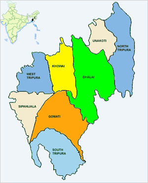
 State Tripura has eight districts namely-Tripura (W), ripura(S), Tripura(N), Dhalai, Unakoti, Gomati, Sepahijala & Khowai. Punjab National Bank has the Lead District Responsibility in the above eight districts. 60% of the total area of Tripura is covered under hill and forest. Govt. recently started distribution of patta to landless farmers in forest land which will be encouraging for the tribal people for movement towards improved farming. Tripura is located in the North Eastern Region of India. The State is connected with Guwahati, by National Highway (NH-44) – the distance between Guwahati and Agartala being about 587 km. Siliguri of W.B is about 1065 Km. away from capital Agartala. Agartala is now connected by Railway Line up to Guwahati. The State Capital, Agartala is also well connected by Air to Kolkata, Delhi, Mumbai, Guwahati and other parts of the country. Agartala Airport is the second busiest Airport in the North East, after Guwahati. |
| Tripura State | |
|---|---|
| Districts | General Information |
Names of the districts
No. of Blocks - 58 No. of Autonomous Councils -1 Total no of Branches - 508 Average population covered per branch:: 7225 (Including RRB & Co-operative Banks) Lead Bank of 8 Districts Punjab National Bank |
Land Utilization- Convener of SLBC Punjab National Bank |
|
Map Linkage Geographical Map of Tripura - Districts in the map to be linked with respective district websites. On clicking at the particular district in the map, user to be redirected to the respective district websites.The links to be embedded in the map are as follows:
|
|||||||||||||||||||||||||||
Archives
|
|||||||||||||||||||||||||||